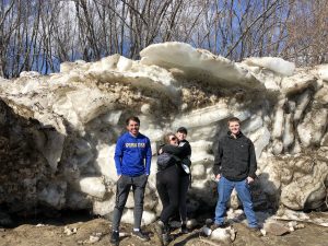
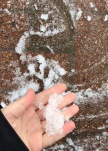
In the fall, the Pemigewasset River saw very significant flooding, and some of campus was even under water! The river eventually froze but in the spring the ice melted and we saw some pretty significant ice jams along the river, but nothing too dangerous. When I hiked to Secret Beach on Easter, the ice was piled very high along the river bank. We had to climb down a wall of ice to make it to the beach and once we did, the water was freezing. With recent high temperatures, all of the ice from Easter has melted. This left little to no beach area and very cold water, but my friends and I still went to soak up some sun. It always amazes me how fast ice can melt. Here is a picture of Secret Beach on Easter vs this past week:

For flood outlooks for the Pemi, click here.
When I looked outside my dorm room window this week, I was pleasantly surprised. The warm temperatures and sunny weather have finally produced buds on the trees, with many sprouting leaves. The mountains are beginning to look less purple and more green and the grass is starting to look very lush. Even though the winter felt like it would never end, all of the elements we love about warm weather are with us again. Everyone is so used to campus looking barren, dull, and cold. But with the trees sprouting their leaves, campus is much brighter and vibrant. People are outside much more often doing their work or enjoying lawn games, and many are tying hammocks on the trees, finally able to enjoy their shade. My favorite type of tree resides outside of Memorial Hall. I snapped a couple photos of it this week:


To learn about other tree types in New Hampshire, click here.
This weekend is Spring Fling at Plymouth State! Will the events be able to survive the weather? On Thursday we had a battle of the bands that was supposed to be on the Alumni Green Lawn but was relocated to the HUB Courtroom because of rain we saw throughout the day. Friday campus saw even more precipitation, and there was a period in the evening where it down-poured as the winds gusted up to about 40mph! This only lasted about 5-10 minutes, but it was an intense taste we got of the line of storms that came east through New York and Vermont. Vermont was under a tornado watch all day on Friday and New Hampshire was under a severe thunderstorm watch. Vermont experienced very intense storms but they mostly traveled north by the time they reached us and we didn’t experience any thunder. Saturday night is the big EDM concert on Mary Lyon lawn, and is the main event of Spring Fling. Luckily, no more thunderstorms are being forecasted. By the time of the concert it will be clear skies and a mild 60 degrees.
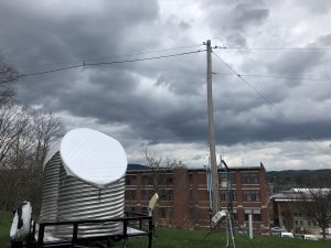
Here is a picture of some threatening clouds I caught on campus Friday:
A recent site that I found for forecasting is turning out to be one of my favorites yet. To explore it for yourself, click the link below.
Today Plymouth reached a high of 90 degrees F, a temperature that is usually unheard of for the start of May. The average high temperature for the area around this time of year is about 63 degrees F. So, this was a very significant weather event. Tomorrow it will stay warm, but a front is expected to pass through. With the frontal passage, we could see some thunderstorms in the area throughout the afternoon tomorrow as well as throughout the day Friday.
We lucked out with a taste of summer-like temperatures today, but it looks like next week the temperatures will return to normal, seasonal temperatures of highs in the 60s. This is nice though, because sunny skies look like they will be accompanying these temperatures in the forecast.
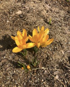
Here is a photo I captured of flowers blooming on campus, in response to the warm temperatures and sun.
Mild temperatures have finally been sticking around here at Plymouth. We saw temperatures break 70 last week, and today we reached a high of 68. I love the sun but my favorite part about the nice weather was the cumulus clouds associated with it. Cumulus clouds are my favorite type of cloud. They are the bright, puffy, white clouds we usually see when it’s nice out. Their lifted condensation level, the height at which an air parcel becomes saturated, is always clearly visible, which allows them to have an aesthetically pleasing flat bottom. Other clouds that are often associated with good weather are cirrus clouds, cirrostratus clouds, and altocumulus clouds. Cirrus clouds are the wispy clouds we see really high in the sky, often associated with sunsets. Cirrostratus clouds are also really high up. They are very thin and can often produce optical illusions such as sun halos and rainbow clouds due to their ice crystals. Altocumulus clouds are mid-level clouds that look similar to regular cumulus clouds, but are less puffy and form in groups.
Aside from fair weather, the clouds associated with poor weather are mainly stratus and cumulonimbus clouds. Stratus clouds are low, gray clouds that make everything look dreary and wet. The cumulonimbus cloud is the thunderstorm cloud. Cumulonimbus clouds can grow to be huge in both width and height. They can grow up to 10 km high and have a flat top, due to the high winds that are high up in the atmosphere. These can produce heavy rain, snow, hail, lightning, and even tornadoes. Hopefully here at Plymouth we can stick to only the fair weather clouds! Although I do love a good thunderstorm.
To learn more about the cloud types and my source, click here: https://scied.ucar.edu/webweather/clouds/cloud-types
Here is a photo of today’s cumulus clouds on campus:

We’ve all heard the saying “April showers bring May flowers!” But Plymouth hasn’t been experiencing normal spring-like April showers. Instead, we’ve experienced a more unpleasant wintry mix, rare for late April! Today, April 16th, classes were delayed and inclement weather impacted campus throughout the entirety of the day. When I went to bed last night a thick layer of ice developed on the window of my dorm from freezing rain. Plymouth was under a winter weather advisory as well as a wind advisory.
Walking to class was nothing but brutal. It was on-and-off sleeting all day and the high winds made sure the ice was pelted into your face. Everyone had wet, soggy shoes because once you were done sliding down a walkway, you were greeted by a pool of slush. Everyone is frustrated with the winter that will never seem to end. Hopefully May will bring warmer temperatures and flowers, despite all of this late wintry weather. There does seem to be a light at the end of the tunnel, though. By the end of this week Plymouth is expected to see sunny skies and temperatures in the 60s. From the Weather Channel, here is proof.
Here are some photos I took of the sleet on campus today.
We’re seeing lots of smiling faces around Plymouth’s campus lately! Despite the fact that a lot of Plymouth’s student body likes to ski, I think we were all very ready for spring! Meteorological spring began on March 1st but it wasn’t until astronomical spring (March 21st) where Plymouth began experiencing some actual spring-like weather. This past week we’ve felt very mild, 50 degree temperatures along with warm sun to wash away our winter blues. Studies show that people who live in the northern latitudes tend to be very vitamin D deprived because they receive much less solar radiation than midlatitudes. The sun is the greatest natural source of vitamin D, which is a vitamin that has been proven to boost serotonin levels in the brain and elevate mood!
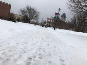
It’s so nice to finally have most of the snow gone and see grass again–a thing that, after a long winter of nor’easters, seems so foreign. People have been breaking out the longboards and roller blades around campus and are taking advantage of the nice weather. It’s wonderful to see people out of their dorms and enjoying being outside again. The overall vibe of the campus seems a lot brighter and happier. Hopefully the mild temperatures stick around!
Here is a link to check out our long-range forecast yourself:
https://www.wunderground.com/forecast/us/nh/plymouth?cm_ven=localwx_10day

A photo I took of Boyd Science Center yesterday when we experienced sun and a high of 55
Welcome! I’m an undergraduate Meteorology major at Plymouth State University and in this blog I’ll be talking all about the weather we experience here in Plymouth, New Hampshire. Today I’ll be discussing the nor’easter that we endured last Tuesday, March 13th. This was the third nor’easter to strike the northeast, and it brought blizzard conditions to much of New England, especially the coast. Here in Plymouth we were under a winter storm warning and meteorologists were predicting that we could’ve seen anywhere from ten to fifteen inches of powder. Well, while many New Hampshire counties did experience hefty snowfall amounts, the university did not. PSU took action and heeded the warnings by cancelling all classes for the 13th and calling a snow day. However, the road conditions outside and around campus seemed up to par throughout the entirety of the day. It turns out we only received about five inches of snow.
So, why did this happen? A Meteorology grad student explained to me that it had to do with the weather phenomenon called “down sloping.” A lot of snow fall forecasts don’t take the valleys into account. Because PSU is surrounded by so many mountains, the flakes are huge a couple thousand feet up, but evaporate by the time they reach us. So, we ended up having pretty small snowflakes throughout the entirety of the storm, which resulted in much lower snowfall amounts than predicted. But, it’s good that the university always stays on the safe side by heeding winter storm warnings. Aside from Winter Storm Skylar, it looks as though Plymouth could experience yet another nor’easter next week!
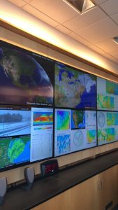
Here is a photo of the map wall in the Plymouth State Weather Center on the day of Winter Storm Skylar. The link to our weather center website is http://vortex.plymouth.edu/